
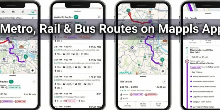
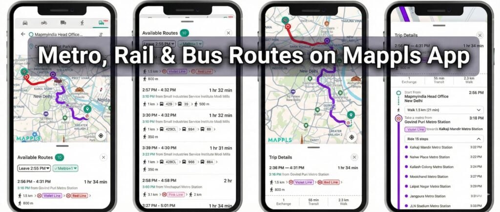
MapmyIndia Mappls Launches Multimodal Public Transport Routes for Smarter Commuting
MapmyIndia Mappls, India’s leading digital mapping and location-intelligence company, has announced a significant expansion of its flagship Mappls App. The platform now features multimodal public transport routes, integrating metro, rail, and bus information directly into its interface. This update positions Mappls as a comprehensive mobility platform that seamlessly brings together private and public transport experiences within a single, indigenous app.
Enhancing Urban Mobility in India
With a user base exceeding 40 million, Mappls now empowers commuters to plan more efficient and sustainable journeys. The new feature allows users to view:
- Detailed public transport routes.
- Specific stations and stops.
- Interchange options for seamless transitions between different modes of travel.
This integration is a direct response to user feedback, aimed at making the app more inclusive and accessible for every citizen. By providing easy access to public transit data, Mappls seeks to encourage the adoption of mass transit, which contributes to reduced traffic congestion and lower carbon emissions in urban areas.
City Coverage and Platform Availability
The multimodal feature is currently being rolled out across 18 major Indian cities:
| Region | Cities Covered |
| North | Delhi, Chandigarh, Lucknow, Kanpur, Agra, Jaipur, Patna |
| West | Mumbai, Pune, Ahmedabad, Nagpur, Indore, Bhopal |
| South | Bengaluru, Chennai, Hyderabad, Kochi |
| East | Kolkata |
The feature is presently live for iOS and Web users, with an Android rollout scheduled to follow shortly.
A Commitment to Indigenous Innovation
As a “fully indigenous” platform built in India for India, MapmyIndia Mappls remains dedicated to supporting the nation’s focus on sustainability. The public transport feature complements existing capabilities such as:
- Turn-by-turn navigation.
- Real-time traffic updates.
- Safety alerts and intelligent routing.
The company continues to work with transport authorities and ecosystem partners to further enrich data and expand coverage across more cities.
Frequently Asked Questions
Which public transport modes are covered in the Mappls App update?
The update includes comprehensive route information for metro, rail, and bus services.
Is the multimodal feature available on Android?
As of late December 2025, the feature is live on iOS and Web. An Android version is planned for release in the near future.
How does Mappls help with sustainable travel?
By integrating public transport options, Mappls helps commuters choose mass transit over private vehicles, which helps reduce urban pollution and traffic congestion.
What specific details can I see for my trip?
Users can access trip details including estimated travel time, specific metro lines (e.g., Violet Line, Red Line), the number of stations, and walking distances to stops.
Is the Mappls App free to use?
Yes, the Mappls App is a free indigenous navigation platform available for download at www.mappls.com/getapp.
You can add more to this story by commenting below.


